National Hurricane Center
Wednesday, September 20, 2017
SUMMARY OF 500 PM AST...2100 UTC...INFORMATION
----------------------------------------------
LOCATION...18.8N 67.3W
ABOUT 25 MI...45 KM NNW OF AGUADILLA PUERTO RICO
ABOUT 75 MI...120 KM E OF PUNTA CANA DOMINICAN REPUBLIC
MAXIMUM SUSTAINED WINDS...110 MPH...175 KM/H
PRESENT MOVEMENT...NW OR 305 DEGREES AT 12 MPH...19 KM/H
MINIMUM CENTRAL PRESSURE...957 MB...28.26 INCHES
WATCHES AND WARNINGS
--------------------
CHANGES WITH THIS ADVISORY:
The Hurricane Warning for the U.S. Virgin Islands has been
discontinued.
The government of Antigua and Barbuda has discontinued the
Hurricane Warning for the British Virgin Islands.
SUMMARY OF WATCHES AND WARNINGS IN EFFECT:
A Hurricane Warning is in effect for...
* Puerto Rico, Culebra, and Vieques
* Dominican Republic from Cabo Engano to Puerto Plata
* Turks and Caicos Islands and the Southeastern Bahamas
A Tropical Storm Warning is in effect for...
* Dominican Republic west of Puerto Plata to the northern border of
the Dominican Republic and Haiti
* Dominican Republic west of Cabo Engano to Punta Palenque
A Hurricane Watch is in effect for...
* Dominican Republic from Isla Saona to Cabo Engano
DISCUSSION AND 48-HOUR OUTLOOK
------------------------------
At 500 PM AST (2100 UTC), the eye of Hurricane Maria was located
near latitude 18.8 North, longitude 67.3 West. Maria is moving
toward the northwest near 12 mph (19 km/h), and this general motion
with a decrease in forward speed is expected through Thursday night.
A turn toward the north-northwest is forecast on Friday. On the
forecast track, the center of Maria will continue to move away from
the northwestern coast of Puerto Rico this evening. The center will
then pass offshore of the northeastern coast of the Dominican
Republic tonight and Thursday and then move near the Turks and
Caicos Islands and southeastern Bahamas Thursday night and Friday.
Data from an Air Force Reserve Hurricane Hunter aircraft indicate
that maximum sustained winds are near 110 mph (175 km/h) with higher
gusts. Some strengthening is forecast during the next day or two,
and Maria could regain major hurricane status by Thursday.
Hurricane-force winds extend outward up to 60 miles (95 km) from the
center, and tropical-storm-force winds extend outward up to 150
miles (240 km).
The minimum central pressure based on data from the Air Force
aircraft is 957 mb (28.26 inches).
HAZARDS AFFECTING LAND
----------------------
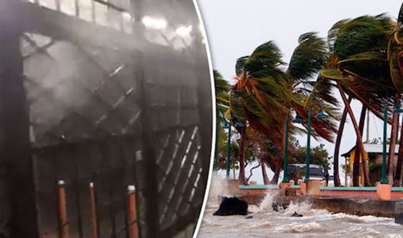
WIND: Hurricane and tropical storm conditions are still occurring
over portions of Puerto Rico. Tropical storm conditions are
spreading across the warning areas in the Dominican Republic, and
hurricane conditions should start in the hurricane warning area
tonight. Tropical storm conditions are expected to begin in the
Turks and Caicos Islands and the southeastern Bahamas on Thursday,
with hurricane conditions starting Thursday night.
STORM SURGE: The combination of a dangerous storm surge and the
tide will cause normally dry areas near the coast to be flooded by
rising waters moving inland from the shoreline. The water is
expected to reach the following heights above ground if the peak
surge occurs at the time of high tide...
Puerto Rico...3 to 5 ft
The deepest water will occur along the immediate coast in areas of
onshore wind over western portions of Puerto Rico, where the surge
will be accompanied by large and destructive waves. Surge-related
flooding depends on the relative timing of the surge and the tidal
cycle, and can vary greatly over short distances. For information
specific to your area, please see products issued by your local
National Weather Service forecast office.
A dangerous storm surge accompanied by large and destructive waves
will raise water levels by as much as 4 to 6 feet above normal tide
levels in the hurricane warning area in the Dominican Republic, and
1 to 3 ft elsewhere along the northern coasts of the Dominican
Republic and Haiti.
A dangerous storm surge accompanied by large and destructive waves
will raise water levels by as much as 9 to 12 feet above normal
tide levels within the hurricane warning area of the southeastern
Bahamas and the Turks and Caicos Islands.
RAINFALL: Maria is expected to produce the following rainfall
totals through Friday:
Puerto Rico...20 to 25 inches, isolated 35 inches
U.S. and British Virgin Islands...additional 3 to 5 inches
Northern and eastern Dominican Republic, Turks and Caicos and
southeast Bahamas...8 to 16 inches, isolated 20 inches
Northern Haiti...2 to 4 inches
Rainfall on these islands will cause life-threatening flash floods
and mudslides
SURF: Swells generated by Maria are affecting the Leeward Islands,
Puerto Rico, and the Virgin Islands. These swells will begin
affecting the northern coast of Hispaniola, the Turks and Caicos
Islands, and the Southeastern Bahamas during the next day or two.
These swells are likely to cause life-threatening surf and rip
current conditions. Please consult products from your local weather
office.