National Hurricane Center
Tuesday, March 10, 2015
SUMMARY OF 1200 PM
-----------------------------------------------
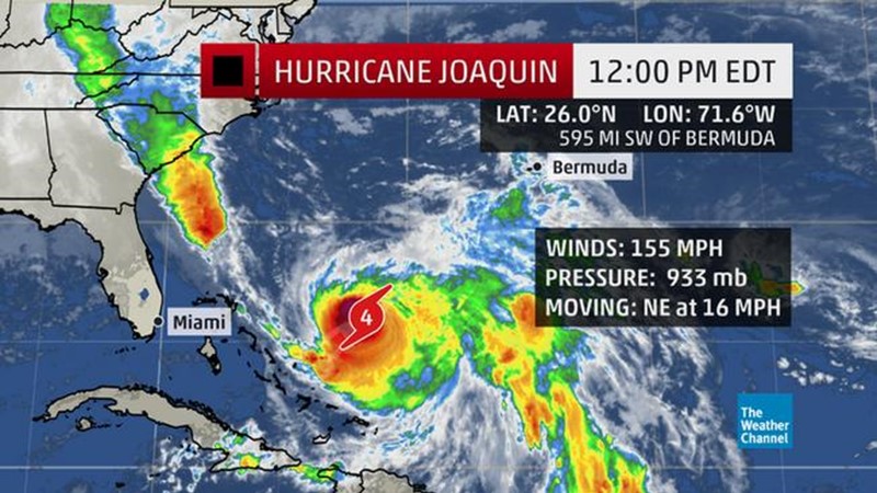
LOCATION...26.0N 71.6W
ABOUT 595 MI...960 KM SW OF BERMUDA
ABOUT 230 MI...365 KM NE OF SAN SALVADOR
MAXIMUM SUSTAINED WINDS...155 MPH...250 KM/H
PRESENT MOVEMENT...NE OR 50 DEGREES AT 16 MPH...26 KM/H
MINIMUM CENTRAL PRESSURE...933 MB...27.55 INCHES
WATCHES AND WARNINGS
--------------------
CHANGES WITH THIS ADVISORY:
None.
SUMMARY OF WATCHES AND WARNINGS IN EFFECT:
A Tropical Storm Warning is in effect for...
* Bermuda
A Hurricane Watch is in effect for...
* Bermuda
A Tropical Storm Warning means that tropical storm conditions are expected somewhere within the warning area. For Bermuda, the tropical storm conditions are expected within the next 36 hours.
A Hurricane Watch means that hurricane conditions are possible within the watch area. A watch is typically issued 48 hours before the anticipated first occurrence of tropical-storm-force winds, conditions that make outside preparations difficult or dangerous.
For storm information specific to your area, please monitor products issued by your national meteorological service.
DISCUSSION AND 48-HOUR OUTLOOK
------------------------------
At 1200 PM EDT (1600 UTC), the eye of Hurricane Joaquin was located near latitude 26.0 North, longitude 71.6 West. Joaquin is moving toward the northeast near 16 mph (26 km/h), and this motion is expected to continue through tonight with an increase in forward speed. A turn toward the north-northeast is forecast on Sunday. On the forecast track, the eye of Joaquin will continue to move away from the Bahamas today, and pass west of Bermuda on Sunday. However, a small deviation to the east of the forecast track would bring the core of the hurricane and stronger winds closer to Bermuda.
An Air Force Hurricane Hunter plane just indicated that the maximum sustained winds have increased to near 155 mph (250 km/h) with higher gusts. Joaquin is a strong category 4 hurricane on the Saffir-Simpson Hurricane Wind Scale. A gradual weakening is still anticipated during the next couple of days.
Hurricane force winds extend outward up to 70 miles (110 km) from the center and tropical storm force winds extend outward up to 205 miles (335 km).
The minimum central pressure recently reported by a reconnaissance plane was 933 mb (27.55 inches).
HAZARDS AFFECTING LAND
----------------------
WIND: Gusty winds will continue to affect portions of the central and southeastern Bahamas today. Tropical storm conditions are first expected to reach Bermuda by Sunday morning, with hurricane conditions possible by Sunday afternoon.
STORM SURGE: Water levels should continue to slowly subside today as Joaquin moves away from the Bahamas.
RAINFALL: Joaquin is expected to produce additional rain accumulations of 2 to 5 inches over the Bahamas, eastern Cuba, Haiti, the Dominican Republic, and the Turks and Caicos Islands through today. Isolated maximum storm-total amounts of 25 inches are possible in the central Bahamas. Outer rain bands of Joaquin will begin to affect Bermuda by early Sunday, and Joaquin is expected to produce 3 to 5 inches of rainfall over Bermuda through Monday. This rainfall could result in life-threatening flash floods.
SURF: Swells generated by Joaquin will continue to affect portions of the Bahamas during the next few days. Swells are affecting much of the southeastern coast of the United States and will spread northward along the east coast of the United States through the weekend. Swells from Joaquin will begin affecting Bermuda today and continue through the weekend. These swells are likely to cause life-threatening surf and rip current conditions. Even though Joaquin is expected to pass well east of the coast of the United States, a prolonged period of elevated water levels and large waves will affect the mid-Atlantic region, causing significant beach and dune erosion with moderate coastal flooding likely. Please consult products from your local weather office.